California Camping
California Camping SitesNational Parks of California
California State Parks
State Parks Camping Fees
State Parks Day Use Fees
State Parks WiFi Access
Pinnacles National Monument - Guide to California's Pinnacles National Monument

Rainbow Falls in Pinnacles National Monument

Entrance to Balconies Cave at Pinnacles National Monument
Pinnacles National Monument is located near Mammoth Mountain in extreme northeastern Madera County in eastern California. It was established in 1911, and protects Devils Postpile, an unusual formation of columnar basalt.
The Monument is divided by the rock formations into East and West Divisions, connected by foot trails; there is no through road that connects the east and west entrances to the park. The east side has shade and water, the west has high walls. The rock formations provide for spectacular pinnacles that attract rock climbers. It is popular with advanced rock climbers due to the many difficult and challenging climbs. The Monument is most often visited in spring or fall because of the intense heat during the summer months.
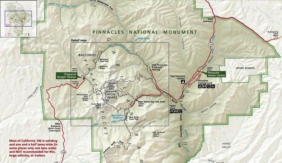
Map of Pinnacles National Monument
Geography of Pinnacles National Monument
An Ancient Volcano

Rock Formations in Pinnacles National Monument
Rising out of the chaparral-covered Gabilan Mountains, east of central California's Salinas Valley, are the spectacular remains of an ancient volcano. Massive monoliths, spires, sheer-walled canyons and talus passages define millions of years of erosion, faulting and tectonic plate movement.
Bird Watching in Pinnacles National Monument
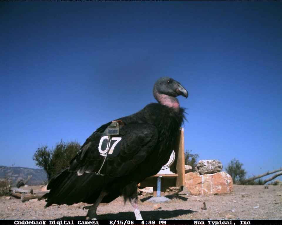
Condors of Pinnacles National Monument
Pinnacles National Monument has been a part of the California Condor Recovery Program since 2003. The park now manages 30 free-flying condors. Each bird is monitored carefully after its release to increase its chances of survival. Management by park biologists helps newly released condors choose safe roosting sites and avoid hazards such as power lines, buildings, roads or trails, and lead-contaminated food.
Updates on Condors
30 condors are flying free over Pinnacles National Monument and beyond. Read updates on the condors and the Pinnacles program.
Where Can I See a Condor?
There are currently 30 free-flying adult and juvenile condors in Pinnacles National Monument. They have commingled with the 27 condors in the Big Sur flock and have effectively become one central California flock. Condors do not migrate and are observed in this area year round. They move frequently within their expanding territory, so they may not always be seen inside the monument.
Pinnacles' condors have now ranged as far as Livermore to the north, Santa Barbara County to the south, and west to the Big Sur coast.
If you are going to visit Pinnacles and you hope to see a condor, one of the most likely viewing areas is the High Peaks in the early morning or early evening. The High Peaks can be reached from either entrance to the park, but keep in mind that hiking to the High Peaks is strenuous. Please carry and drink plenty of water, wear layered clothing, and be prepared for temperature extremes.
Another location that the condors spend time around is the ridge just southeast of the campground. Condors are often observed soaring on the morning thermals along the ridge and coming in to roost on their favorite trees in the evenings. Two spotting scopes have been placed in the Campground (on the Bench Trail near Pinnacles Visitor Center) that may help you get a closer look at these magnificent birds.
Remember that our condors are free-flying, which means there is no guarantee you will see one on a given day at a given time.
Cave Exploration in Pinnacles National Monument
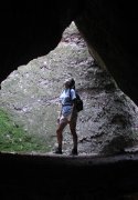
Bear Gulch Cave in Pinnacles National Monument
Status of the Caves
Bear Gulch Cave
Bear Gulch cave is closed. A sensitive colony of Townsend's big-eared bats are reoccupying the cave to raise their young. The cave will be closed until July 16th, depending on the bats situation.
Balconies Cave
The Balconies Cave is open.
These caves can be closed suddenly due to storms and high water. Please
check before your visit to get the most current cave status. Flashlights
are required for both caves.
Information About the Seasonal Opening of the Bear Gulch Cave
The Bear Gulch Cave provides a home to a colony of Townsend's big-eared bats as they hibernate in winter and raise their young in the late spring and summer. Townsend's big-eared bats are listed as a "sensitive species" by the state of California, and we are required to protect them. The colony in the Bear Gulch Cave is the largest maternity colony between San Francisco and Mexico.
The lower half of the Bear Gulch Cave is usually open from mid-July through mid-May each year, depending on the presence of the colony of bats. The entire cave is closed from mid-May to mid-July while the bats are raising their young.
We have constructed a gate that will allow us to open approximately half of the cave to the public while still protecting the colony of Townsend's big-eared bats. A new trail leaves the middle of the cave and connects with the Moses Spring Trail, which leads to the reservoir.
As long as the hibernating colony of bats shows no signs of disturbance,
we plan to keep over half of the Bear Gulch Cave open for almost ten months
each year, from mid-July through mid-May. During especially warm springs,
however, it's possible that the entire cave will be closed before mid-May
if the maternity colony is present.
The entire cave will continue to be closed through late spring and early summer for pupping season, from mid-May through Mid-July. The entire Bear Gulch Cave will also be open twice a year for at least one week and up to four weeks each March and October, depending on the presence of the colony of bats.
Schedule of the Seasonal Opening of the Bear Gulch Cave
These dates may change if the colony of bats changes its breeding patterns
or shows signs of disturbance.
March The lower half of the cave may be open for the full month. The
entire cave is open for at least a week, usually the last week of the
month. The entire cave may also open earlier, depending on the presence
of the colony of bats.
April 1 - mid-May The lower half of the cave may be open.
Mid-May - mid-July The entire cave will be closed to protect the colony
of bats as they raise their young.
Mid-July - September 31 The lower half of the cave may be open.
October The entire cave is open for at least a week, usually the last
week of the month. The entire cave may also open earlier, depending on
the presence of the colony of bats.
Nov. 1 - end of Feb. The lower half of the cave may be open.
Activities in Pinnacles National Monument
There are several trails for day hikers, some of which are strenuous. The trails provide views of the surrounding hills and valleys on clear days. The San Andreas Fault is visible from some vantages along the trails.
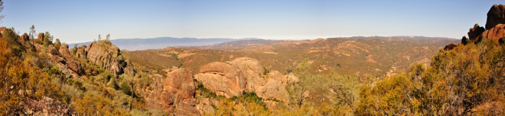
A view from the High Peaks Trail
Pinnacles NM includes a well known hiking portion known among enthusiasts
simply as "The Pig Fence". This portion of South Wilderness
Trail is a challenging stretch of strenuous hiking that at times requires
use of the fence, erected to prevent feral pigs from entering the park,
to help oneself to climb the steeply pitched trail.
Other trails include lush wildflower accented views along flat stream
beds, trails that bring one into beautiful caves, and trails that involve
high vistas of the Pinnacle formations.
Did you know that most of the land within the boundaries of Pinnacles National Monument is classified as wilderness?
This means, when you step on the trail to the High Peaks or to Chalone Peak or Juniper Canyon, North or South Wilderness or even on the Old Pinnacles trail, you’re hiking in areas protected not just by the laws that created and protect national park areas. These trails and the surrounding areas are in the Pinnacles Wilderness, and under the Wilderness Act of 1964, they are given a greater protection from development and are managed for “wilderness values”.
Camping in Pinnacles National Monument
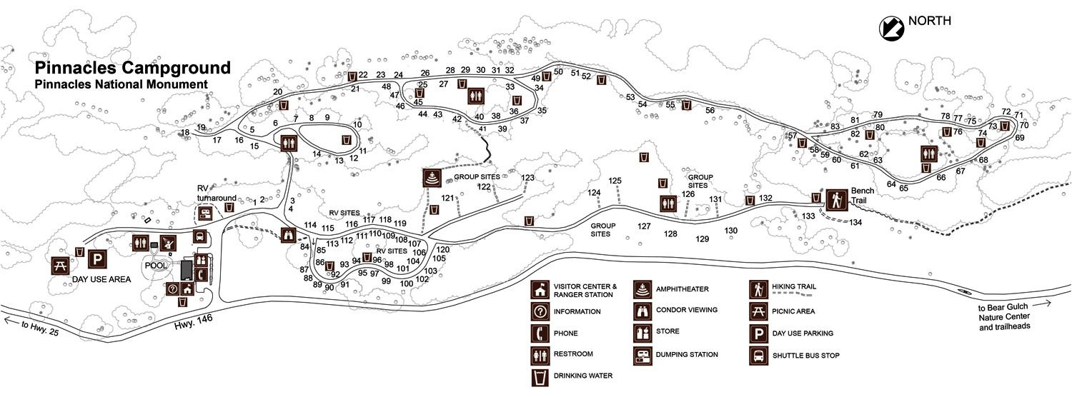
Pinnacles National Monument Campgroud Map
Pinnacles Campground is located on the east side of the monument and
offers tent and group camping, along with RV sites. Each tent and group
site has a picnic table and fire ring. Most RV sites have electrical hookups
and share community tables and barbecue pits. Water is located throughout
the campground. Oak trees provide shade many campsites. Showers and a
dump station are available. The swimming pool is typically open from middle
of April through the end of September, depending on the weather trend.
Pinnacles Campground and the Campground Store are operated by Royal Elk
Park Management, INC.
The Campground Store hours:
Monday-Friday 3:00pm - 6:00pm,
Saturday & Sunday 9:00am - 6:00pm.
Tent and RV sites can be reserved up to 6 months in advance, and group
sites can be reserved up to 12 months in advance.
For reservations, please visit recreation.gov or call (877) 444-6777.
For more information, please call the Pinnacles Campground Store at (831) 389-4538.
Trails of Pinnacles
Bear Gulch Trail
Pinnacles National Monument has more than 30 miles of trails, ranging from easy to strenuous. Many trails intersect, and you can plan a short loop or a longer all-day trip. Popular destinations are Bear Gulch Reservoir, High Peaks, and the Balconies area.
Trails from Pinnacles Campground
Trails from Bear Gulch Day Use Area
Trails from Old Pinnacles Trailhead
Trails from Chaparral (west entrance)
Trails from Pinnacles Campground
Pinnacles Visitor Center to Bear Gulch Day Use Area
2.7 miles one way - Moderate
elevation gain: 300 feet
Walk along Chalone and Bear creeks from the visitor center to the Bear Gulch Day Use Area. Portions of the Bench Trail are accessible to visitors in wheelchairs.
South Wilderness Trail
1 mile to junction and up to 3 miles one way– Easy to moderate
No elevation gain
This level trail is a good choice for hikers who are looking to get away from the park’s more popular trails. You can hike to the park boundary, or simply meander through the grove of valley oaks. This trail is and excellent choice for bird and other wildlife viewing.
Pinnacles Visitor Center to Balconies Cave
4.3 miles one way - moderate
elevation gain: 300 feet
Walk 2.3 miles along the flat and easy Bench Trail to the Old Pinnacles Trail junction, and after the trails merge, it is another two miles to Balconies Cave. Flashlights are required in the cave, and be prepared to scramble through talus passages. On the way back, double back over the cave on theBalconiesCliffsTrailfor views of the largest rock formations in the park.
Trails from Bear Gulch Day Use Area
Moses Spring–Rim Trail Loop
2.2 mile loop, 1 1/2 hours
elevation gain: 500 feet
Moderate
This loop is a good choice for rock formations, talus caves, and the reservoir on a short hike and also a good choice for children. Bear Gulch Cave is open seasonally. Flashlight required in cave.
Condor Gulch–High Peaks Loop
5.3 mile loop, 3 to 5 hours
elevation gain: 1,300 feet
Strenuous
Walk through the heart of the Pinnacles rock formations, particularly along the Steep and Narrow section of the High Peaks Trail. Add the Rim and Moses Spring trails to extend the loop to 6.1 miles.
High Peaks–Bear Gulch Loop
6.7 mile loop, 4 to 5 hours
elevation gain: 1,425 feet
Strenuous
Climb into the High Peaks and descend along the ridge through meadows of grasses and, in spring, wildflowers. Return to the Bear Gulch Day Use Area under the shade of sycamores along the Bear Gulch Trail.
Bench Trail–Bear Gulch Trail
2.3 miles one way, 1 1/2 hours
elevation gain: 300 feet
Moderate
Walk along Chalone and Bear creeks from the campground to the Bear Gulch Day Use Area. Portions of the Bench Trail are accessible to visitors in wheelchairs.
Condor Gulch Trail
1.7 miles one way, 1 to 11/2 hours
elevation gain: 1,100 feet
Moderate to Overlook, strenuous beyond
This trail offers spectacular views of the High Peaks, whether you hike just a few minutes or the entire trail. The Overlook is one mile up. Ask about a geology trail guide.
Chalone Peak Trail
8.6 miles round trip, 3 to 5 hours
elevation gain: 2,040 feet
Strenuous
Climb to the highest point in the park, North Chalone Peak, and b rewarded with views of the surrounding valleys. Continue on an unmaintained trail to South Chalone Peak for a longer hike.
Trails from Old Pinnacles Trailhead
Old Pinnacles Trail to Balconies Cave
6.3 miles round trip, 3 to 4 hours
Minimal elevation gain
Moderate
This sunny hike to Balconies Cave also leads to towering rock formations: Machete Ridge and the Balconies Cliffs. Begin at the Old Pinnacles trailhead parking area. Flashlight required in cave.
South Wilderness Trail
6.5 miles round trip, 3 to 4 hours
no elevation gain
Moderate
Follow this unmaintained trail to the park boundary, or simply meander through the magnificent grove of valley oaks. Begin at the Bench Trail or the campground and turn at South Wilderness marker.
Trails from Chaparral Parking Area (west entrance)
Balconies Cliffs–Balconies Cave Loop
2.4 mile loop, 1 to 1 1/2 hours
elevation gain: 100 feet
Easy to Moderate
This trail through Balconies Cave may require a bit of scrambling through talus passages. Wading may be required in winter. Flashlight required in cave.
Juniper Canyon Loop
4.3 mile loop, 2 to 3 hours
elevation gain: 1,215 feet
Strenuous
This steep trail climbs along switchbacks to the heart of the High Peaks. At the top, circle through the rock formations along the Steep and Narrow section of the High Peaks Trail and the Tunnel Trail.
North Wilderness Trail Loop
9.7 mile loop, 5 to 8 hours
elevation gain: 1,020 feet
Strenuous
This unmaintained trail climbs along ridgetops and then descends into the Chalone Creek bed, where it is marked by rock cairns. Return along the Old Pinnacles and Balconies trails.
High Peaks–Balconies Cave Loop
8.4 mile loop, 4 to 5 hours
elevation gain: 1,540 feet
Strenuous
Begin by climbing into the High Peaks, and the rest of the loop is downhill or flat. Return along the Old Pinnacles and Balconies trails, going over or through the cave. Flashlight required in cave.
Climate in Pinnacles National Monument
Below is the current temperature and weather forcast for Pinnacles National Monument
Elevation within the boundaries range from 824 feet (251 m) to 3,304 feet (1,007 m) at the peak of North Chalone Peak.
The climate is Mediterranean, typical on the Southern and Central California coast. The Santa Lucia Mountains lie between the Monument and Pacific Ocean, blocking much of the moderating influence of the Ocean. In comparison to the nearby coast, temperatures have a daily larger range that can be 50 �F to 100 �F (10 �C to 38 �C). The average rainfall is about 16 inches (410 mm) per year. Snow can fall in small amounts at higher elevations between mid-December and January. The National Weather Service has a cooperative weather station at the park headquarters. Average January temperatures are a maximum of 60.8 �F (16.0 �C) and a minimum of 32.8 �F (0.4 �C). Average July temperatures are a maximum of 95.5 �F (35.3 �C) and a minimum of 50.3 �F (10.2 �C). The record high temperature was 116 �F (47 �C) on July 15, 1972.
Location of Pinnacles National Monument
The Pinnacles National Monument can be contacted at (831) 389-4486. For the location use following GPS cordinates of Pinnacles National Monument 36°29'13"N 121°10'1"W. The official address of Pinnacles National Monument is Pinnacles National Monument, 5000 Highway 146, Paicines, CA 95043-9762. However, use following address to get driving directions to Chalone Creek Rd, PAICINES, CA 95043. and the map is shown below:
Here is a detailed list of other National Parks of California besides Pinnacles National Monument.
| National Parks of California | |||||||||||||||||||||||||
|---|---|---|---|---|---|---|---|---|---|---|---|---|---|---|---|---|---|---|---|---|---|---|---|---|---|
|
|||||||||||||||||||||||||
Camping Resources
Free Services
Free Text MessagesFree Picture Messages
Free Fax
Free Calls