Joshua Tree National Park - Guide to California's Joshua Tree National Park
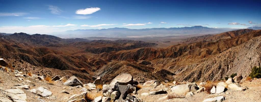
Panorama of the view south from the popular Keys View in the Little San Bernardino Mountains, Joshua Tree National Park, California. Visible landmarks are the Salton Sea (230 ft/70 m below sea level) at rear left, along towards the center the Santa Rosa Mountains behind Indio and the San Jacinto Mountains behind Palm Springs. In the valley floor, the San Andreas Fault is clearly visible. At the rear right is the 11,500 ft (3,500 m) San Gorgonio Mountain.
Recreation at Joshua Tree National Park
Nine established campgrounds exist in the park, only two of which (Black
Rock Canyon and Cottonwood) provide water and flush toilets. A fee is
charged per night for each camping spot. Backcountry camping, for those
who wish to backpack, is permitted with a few regulations.
Hiking
There are several hiking trails within the park, many of which can be accessed from a campground. Shorter trails, such as the one mile hike through Hidden Valley, offer a chance to view the beauty of the park without straying too far into the desert. A section of the California Riding and Hiking Trail meanders for 35 miles through the western side of the park. The lookout point at Keys View, towards the south of the park, offers views of the Coachella Valley and Salton Sea.
Nature walks inside the park include:
Hidden Valley
Indian Cove
Cholla Cactus Garden
Longer trails include:
Boy Scout Hiking and Equestrian Trail
Lost Horse Mine
Lost Palms Oasis
Fortynine Palms Oasis
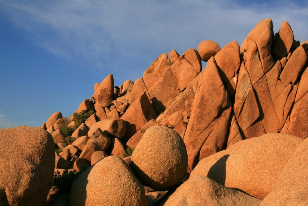
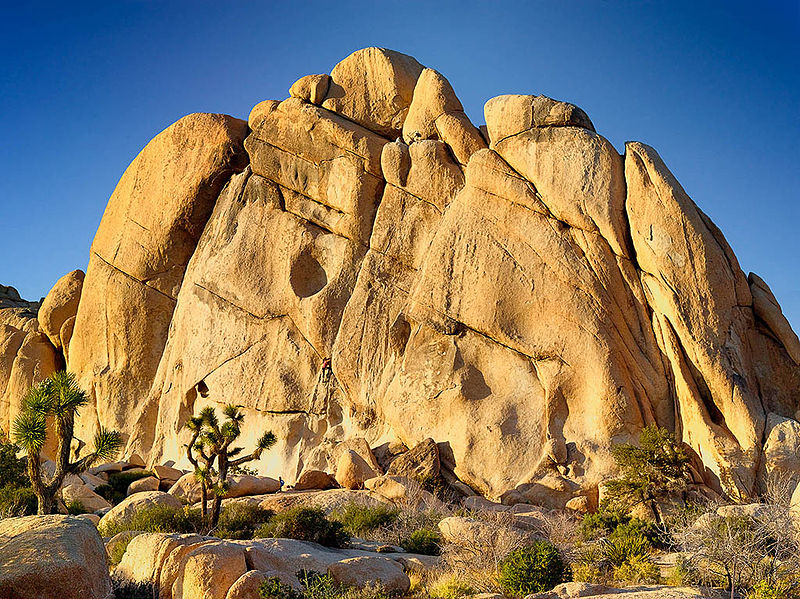
Climbing
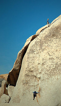
The park is popular with rock climbers and was originally a winter practice
area while Yosemite Valley and other parts of the Sierra Nevada were snowbound,
but later became an area of interest in its own right. There are thousands
of named climbing routes, at all levels of difficulty. The routes are
typically short, the rocks being rarely more than 230 ft (70 m) in height,
but access is usually a short, easy walk through the desert, and it is
possible to do a number of interesting climbs in a single day. The rocks
are all composed of quartz monzonite, a very rough type of granite made
even more so as there is no snow or ice to polish it as in places like
Yosemite.
Driving
The Geology Motor Tour is located in the south of the park and provides
a self-guided tour for those visitors with a four-wheel drive vehicle.
There are sixteen stops on the tour showcasing the region's geology.
Birding
There are over 250 species of bird in the park including resident desert birds such as the Greater Roadrunner and Cactus Wren as well as Mockingbirds, Le Conte's Thrasher, Verdin and Gambel's Quail. There are also many transient species that may spend only one or two seasons in the park. Noted birding spots in the park include: fan palm oases, Barker Dam and Smith Water Canyon. Queen Valley and Lost Horse Valley also provide good birding but with a different range of species because of the lack of water. These are often good places to see Ladder-backed Woodpecker and Oak Titmouse. A USGS Bird Checklist of "what, when, and status" has 239 species listed for the park.
Residents, Migrants, and Nesters Birds
Joshua Tree’s resident bird species, such as greater roadrunner, phainopepla, mockingbird, verdin, cactus wren, rock wren, mourning dove, Le Conte’s thrasher, and Gambel’s quail can be sighted in the park throughout the year. The park’s winter migrants: white-crowned sparrow, dark-eyed junco, sage sparrow, cedar waxwing, American robin, and hermit thrush will remain in the park into March. Along about the time the winter migratory species are departing, other species will begin to migrate into the area for spring and summer. This group includes summer nesting species such as Bendire’s thrasher, ash-throated flycatcher, western kingbird, Scott’s oriole, northern oriole, and western bluebird.
Transients Birds
A brightly colored bunch of warblers: Wilson’s, black-throated gray, Nashville, Mac Gillivray’s, yellow, yellow-rumped (a species also here in winter), and orange-crowned are among the species that just pass through the park. Other transients are black-headed grosbeaks, western tanagers, indigo buntings, and lazuli buntings. In addition to these smaller migrants, the park hosts a migration of birds of prey: sharp-shinned hawk, rough-legged hawk, northern harrier, osprey and Swainson’s hawk. There are several resident hawks as well: red-tailed hawk, American kestrel, Cooper’s hawk, and prairie falcon.
Unusual Sightings of Birds
Occasionally groups of 200 or more turkey vultures will spend the night in the trees at the Oasis of Mara during their spring migration. They present quite a sight especially with their wings slightly spread, warming in the early morning sun. An occasional shore bird also finds its way into Joshua Tree during spring. Do not be too surprised if you see a black-necked stilt or an eared grebe standing on a park road. Grebes have their feet placed so far to the back of their bodies they cannot make a running takeoff on land—once grounded, they are stranded. Please report any sightings to park personnel so the stranded bird can be transported safely to a water site.
Where to Look for Birds in Jashua Tree National Park?
Fan palm oases, and water impoundments are good places to search for birds. Even “lakes” that are dry, such as Barker Dam, offer forage vegetation for birds. The Oasis of Mara, including the 29 Palms Inn at the west end, is a good bird viewing area. Cottonwood Spring has both cottonwood trees and fan palms to provide vegetation and shelter for a number of birds. Lost Palms Oasis, 49 Palms Oasis, and the riparian habitat associated with Smith Water Canyon require more extensive hiking but provide good birding as well. When in the high desert areas of the park take a walk or two in the Queen and Lost Horse valleys and look for ladder-backed woodpecker, red-tailed hawk, oak titmouse, bushtit, black-tailed and blue-gray gnatcatchers, black-throated sparrow, and sage sparrow.
Pickup a Checklist for Birds Viewing
Interested visitors can stop at a visitor center and pick up a bird checklist that will indicate the likelihood of a particular species being observed during each season. Also ask about any interesting bird sightings or report any unusual sightings you might make. Enjoy your park and its birds.
Wildlife
A good place to view wildlife is at Barker Dam, a short hike from a parking
area near Hidden Valley. Desert Bighorn Sheep and Mule Deer sometimes
stop by the dam for a drink. Tours of the Barker Dam area are available.
Wilderness
Of the park's total land area of 789,745 acres (319,598 ha), 429,690 acres (173,890 ha) are designated wilderness and managed by the National Park Service (NPS) in accordance with the Wilderness Act. The NPS requires registration for overnight camping at specific locations called registration boards. Other requirements include the use of a camp stove as open campfires are prohibited and employing Leave No Trace camping techniques (also known as "pack it in, pack it out"). Although bicycles are not allowed in wilderness areas, horses are, but a permit must be obtained in advance for travel in the backcountry.
Death Valley National Park Map and Directions
Park Maps
• Park map with shaded relief (636k PDF)
• Map
on how to locate the JT NP (103k PDF)
Backroad Maps
• Berdoo Canyon Road (56k PDF)
• Geology Tour Road (58k PDF)
• Old Dale/Black Eagle Mine Roads (87k PDF)
• Pinkam Canyon Road (73k PDF)
Trail Maps
• 49 Palms Oasis (36k PDF)
• Barker Dam/Wall Street Mill (168k PDF)
• Hidden Valley (162k PDF)
• Lost Horse Mine/Mountain (46k PDF)
• MastodonPeak/LostPalmsOasis (170k PDF)
• RyanMountain (161k PDF)
Backcountry Trails & Registration Boards
• Black Rock Canyon (640k PDF)
• Cottonwood Spring (381k PDF)
• Covington (433k PDF)
• Geology (652k PDF)
• Indian Cove (409k PDF)
• Juniper Flats (598k PDF)
• Keys West (456k PDF)
• North Entrance (580k PDF)
• Pine City (700k PDF)
• Pleasant Valley (782k PDF)
• Porcupine Wash (325k PDF)
• Turkey Flats (409k PDF)
• Twin Tanks (379k PDF)
Rock Climbing Maps
• Indian Cove (326k PDF)
• Hidden Valley (1.12mb PDF)
• Sheep Pass (211k PDF)
• Queen Valley (307k PDF)
• Geology Tour (301k PDF)
• Split Rock 503k PDF)
• Belle/Whitetank (78k PDF)
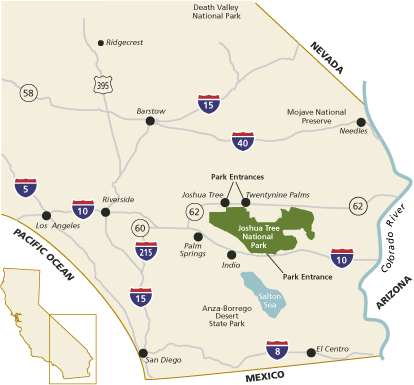
Joshua Tree National Park lies 140 miles east of Los Angeles, 175 miles
northeast of San Diego, and 215 miles southwest of Las Vegas. You can
approach it from Interstate 10 and Hwy 62 (Twentynine Palms Highway).
The closest airport is in Palm Springs. Public transportation to the park
is not available.
There are three park entrance stations:
• The west entrance is located five miles south of the junction of
Highway 62 and Park Boulevard at Joshua Tree Village.
• The north entrance is in Twentynine Palms, three miles south of
the junction of Highway 62 and Utah Trail.
• The south entrance at Cottonwood Spring, which lies 25 miles east
of Indio, can be approached from the east or west, also via Interstate
10.
For your GPS use following address: 74485 National Park Drive, Twentynine
Palms, CA 92277.
Joshua Tree National Park Temperature
Days are typically clear with less than 25 percent humidity. Temperatures are most comfortable in the spring and fall, with an average high/low of 85 and 50°F (29 and 10°C) respectively. Winter brings cooler days, around 60°F (15°C), and freezing nights. It occasionally snows at higher elevations. Summers are hot, over 100°F (38°C) during the day and not cooling much below 85°F (29°C) until the early hours of the morning.
Here is a complete list of other National Parks of California besides Joshua Tree National Park.
| National Parks of California | |||||||||||||||||||||||||
|---|---|---|---|---|---|---|---|---|---|---|---|---|---|---|---|---|---|---|---|---|---|---|---|---|---|
|
|||||||||||||||||||||||||
Camping Resources
Free Services
Free Text MessagesFree Picture Messages
Free Fax
Free Calls