California Camping
California Camping SitesNational Parks of California
California State Parks
State Parks Camping Fees
State Parks Day Use Fees
State Parks WiFi Access
Mojave National Preserve - Guide to California's Mojave National Preserve
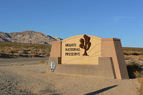
Entrance Sign alongside the Kelbaker Road of Mojave National Preserve
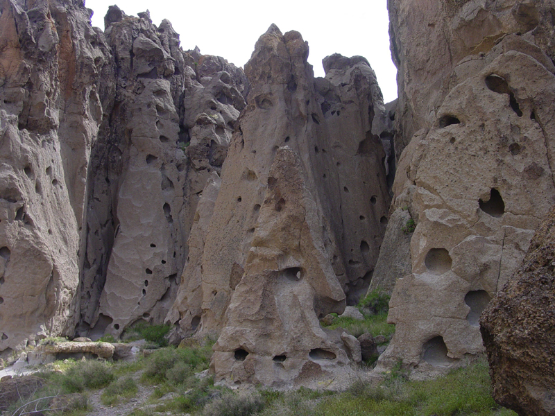
Hole-in-the-Wall canyon in Mojave National Preserve
Mojave National Preserve is located in the Mojave Desert of San Bernardino
County, California, USA, between Interstate 15 and Interstate 40. At 1.6
million acres, Mojave National Preserve is the third largest National
Park Service area outside of Alaska. Death Valley National Park and Yellowstone
National Park rank first and second.
Natural features include the Kelso Dunes, the Marl Mountains and the Cima
Dome, as well as volcanic formations such as Hole-in-the-Wall and the
Cinder Cone Lava Beds. The preserve encloses Providence Mountains State
Recreation Area and Mitchell Caverns Natural Preserve, which are both
managed by the California Department of Parks and Recreation.
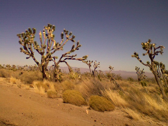
Impressive Joshua Tree forests cover parts of the preserve. The Cima Dome
and Shadow Valley forests are the largest in the world. The defunct railroad
depot and ghost town of Kelso are also found there. The depot is now the
visitor center. The preserve is commonly traversed by 4 wheel drive vehicles
traveling on the historic Mojave Road.
The climate varies greatly. Summer temperatures average 90 °F (32 °C), with highs exceeding 105 °F (41 °C). Elevations in the Preserve range from 7,929 feet (2,417 m) at Clark Mountain to 880 feet (270 m) near Baker. Annual precipitation varies from 3.37 inches (86 mm) near Baker, to almost 9 inches (230 mm) in the mountains. At least 25% of precipitation comes from summer thunderstorms. Snow is often found in the mountains during the winter.
Recreation Mojave National Preserve
Boulder and Joshua trees on Cima Dome
Camping in Mojave National Preserve
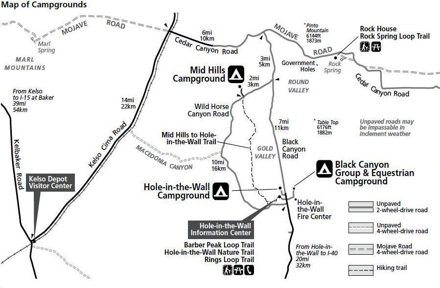
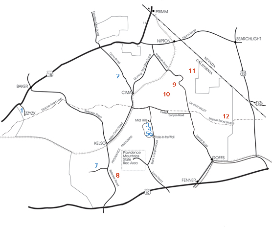
Mojave National Preserve Campground Map
Camping in Mojave National Preserve is an enjoyable and rewarding pastime for visitors of all ages, backgrounds, and experience levels. Developed campgrounds are ideal for families and groups, while roadside camping areas and nearly 700,000 acres of wilderness offer more primitive camping opportunities.
Car camping is available both in developed campgrounds or along roads in sites that have traditionally been used for that purpose. Do not camp along paved roads, and never camp within 200 yards of water sources.
Black Canyon Equestrian & Group Campground (year round), Ph: (760) 928-2572. Located directly across the road from Hole-in-the-Wall Ranger Station and Campground. Facilities include pit toilets, water, and a picnic shelter with tables. Reservations are $25 per night; call (760) 928-2572.
Hole-in-the-Wall Campground (year round), Ph: (760) 928-2572 or (760) 252-6100. Surrounded by sculptured volcanic rock walls, the Hole-in-the-Wall Campground is at 4,400 feet elevation. The 35 campsites are large enough for motorhomes and trailers. Two walk-in tent sites are also available. Facilities include pit toilets, picnic tables, fire rings, trashcans, and drinkable water. There are no utility hookups but there is a dump station. Spaces are available on a first-come, first-served basis for $12 per site per night. Fees for Golden Age/Access Passport holders are $6 per site per night.
Mid Hills Campground, Ph: (760) 928-2572 or (760) 252-6101. Nestled in pinyon pine and juniper trees at 5,600 feet, Mid Hills Campground is much cooler than the desert floor below. The road to the campground is not paved and is not recommended for motorhomes or trailers. There are 26 campsites with picnic tables and fire rings. Pit toilets, trashcans, and drinkable water are * provided. Spaces are available on a first-come, first-served basis for a $12 per site per night fee. Fees for Golden Age/Access Passport holders are $6 per site per night. Some sites are closed due to a recent wildfire.
Providence Mountains State Recreation Area (Mitchell Caverns) offers six campsites on a first-come, first-served basis. Cave tours of the Mitchell Caverns attract many people. This is a small campground that is entirely surrounded by the Preserve, though administratively not part of it. The location is on an east-facing mountain ledge with beautiful views and sunrises, where the wind can sometimes be quite fierce.
For more detailed Mojave National Preserve campsites refer here.
Backcountry
Joshuatrees in Mojave National Preserve Wilderness
Much of the Mojave
National Preserve is designated wilderness area (see map), where mechanized
travel by car or bicycle is prohibited. Only travel by horse or foot is
allowed in these areas. A network of backcountry roads, often suitable
only for four-wheel-drive vehicles or, sometimes, well-equipped mountain
bikes, provides access to many of these areas.
Campsites are often found sporadically along backcountry roads in the
Preserve.
Hiking in Mojave National Preserve
Mojave National Preserve Hiking Trail Map
Although there are few established hiking trails, abandoned dirt roads, washes, and ridge lines offer an abundance of cross-country hiking opportunities.
Numbers on map show general locations of trails and routes listed below.
Blue numbers indicate trails; Red numbers, routes.
DEVELOPED TRAILS
1) Lake Tuendae Nature Trail
Trailhead: Zzyzx parking area, 5 miles south of I-15 on Zzyzx Road.
Enjoy an easy, .25-mile stroll around Lake Tuendae. Wayside exhibits along
the trail reveal the rich cultural history of this oasis on the preserve's
western boundary.
2) Teutonia Peak Trail
Trailhead: 12 miles south of I-15, or 5 miles north of Cima, Calif. on
Cima Road.
Explore the world's largest and densest Joshua tree forest en route to
a rocky peak with expansive views of Cima Dome and beyond. 3 miles round-trip.
3) Mid Hills to Hole-in-the-Wall Trail
Trailheads: Entrance to Mid Hills Campground, and about 1 mile west of
Black Canyon Road on the south end of Wild Horse Canyon Road.
Hike 8 miles, one-way, through a maze of washes decorated with barrel
and cholla cacti, then through the Hackberry Fire burned area. Total elevation
gain is 1,200 feet. Watch carefully for trail route markers.
4) Barber Peak Loop Trail
Trailhead: Parking area for walk-in tent sites at Hole-in-the-Wall Campground.
The preserve’s newest trail, this 6-mile loop encircles Barber Peak
just west of Hole-in-the-Wall Campground, passes the Opalite Cliffs, and
returns to Hole-in-the-Wall via Banshee Canyon.
5) Rings Loop Trail
Trailhead: Hole-in-the-Wall Information Center parking area, 20 miles
north of I-40 on Essex and Black Canyon roads.
Discover how Hole-in-the-Wall got its name as you ascend narrow Banshee
Canyon with the help of metal rings mounted in the rock. The 1.5-mile
round-trip hike connects to the Mid Hills to Hole-in-the-Wall Trail (see
#3, above).
6) Hole-in-the-Wall Nature Trail
Trailhead: Hole-in-the-Wall Information Center and Campground, 20 miles
north of I-40 on Essex and Black Canyon roads.
Learn to identify desert plants on this easy, .5-mile round-trip hike.
Trailheads at Hole-in-the-Wall information Center and Campground.
7) Kelso Dunes
Trailhead: 3 miles west of Kelbaker Road on the well-graded, but unpaved
Kelso Dunes Road.
Hikers at sunrise and sunset are treated to both cooler temperatures and
the rose-colored glow of the dunes. The roughly 3-mile round-trip hike
might take several hours as you slog through the sand, then slide down
the slopes. Moving sands sometimes create a "booming" sound—run
downhill and get the sand moving to hear the sound.
RECOMMENDED ROUTES
Warning: the routes described below are not established trails; trailheads might be unidentifiable or nonexistent. Check a detailed map or guidebook—available at all information centers—and consult a park ranger for route information.
8) Quail Basin
Start: 12.5 miles north of I-40 on Kelbaker Road, then 1 mile east on
an unmarked dirt road. Park at junction with closed dirt road heading
south. High clearance and four-wheel drive recommended.
Follow the route to the south to a road that loops around a small valley.
After walking the loop, return via the same route. The 6.5-mile round-trip
leads past jumbled rocks into a small valley of Mojave yucca and juniper
surrounded by granite outcroppings.
9) Keystone Canyon
Start: 18 miles south of Nipton Road on Ivanpah Road, then 2.5 miles west
on an unmarked dirt road. Bear left at the first fork, right at the second,
then continue to a parking area. Four-wheel drive recommended.
Hike the deteriorating road into Keystone Canyon, ascending the New York
Mountains. Continue cross-country to the top of the ridge for spectacular
views. Watch for pinyon pine, juniper, turbinella oak, and even a few
white fir near the top. Hike a 3 miles one way.
10) Caruthers Canyon
Start: Primitive campsites in Caruthers Canyon, 5.5 miles west of Ivanpah
Road on New York Mountains Road, then 2.7 miles north on an un-signed
road. High clearance and four-wheel drive recommended.
Hike 3 miles one way through one of the Mojave's most bontanically diverse
areas: Conifers, oaks, and coastal chaparral plants including manzanita,
yerba santa, ceanothus, and coffee berry decorate this route.
11) Castle Peaks Corridor
Start: 4.9 miles east of Ivanpah Road on signed Hart Mine Road; left at
fork, then 0.9 miles, left at fork, then 3.4 miles, crossing an earthen
berm; left at fork, then 1 mile more to where road ends. High clearance
and four-wheel drive recommended.
For excellent views of the Castle Peaks spires, walk 4 miles one way up
the closed road to the ridgetop and beyond into a small canyon.
12) Piute Creek
Start: 9.5 miles east of the junction of Lanfair and Cedar Canyon roads
on a dirt utility road, then 0.5 miles north. High clearance and four-wheel
drive recommended.
Hike 6.5 miles round-trip through the colorful Piute Gorge and explore
the ruins of Fort Piute, built and manned in the 1880s to protect mail
and travelers on the Mojave Road. Elliot Coues, an early visitor to Fort
Piute described it as "a Godforsaken Botany Bay of a place-the meanest
I ever saw for a military station." A perennial stream near the fort,
rare in the Mojave, supports riparian plants and animals. Return to your
vehicle via an unused trace of the Mojave Road.
Stay safe in Mojave National Preserve
Carry lots of water. There is very little water available in the Preserve.
Bottled water can be purchased at the lunch counter in the Kelso Depot
Visitor Center, along I-15 in Baker and at the gas station/store at I-15/Cima
Road, at the general store in Nipton, at the Cima store (which isn't always
open), and at the gas station in Fenner near the junction of I-40 and
old Route 66 on the south side of the Preserve.
Public drinking water is available at the Mid Hills and Hole in the Wall
campgrounds, at Mitchell Caverns campground (Providence Mountains State
Recreation Area), and from water fountains at Kelso Depot visitor center
washrooms (open 24 hours a day) or inside Kelso Depot during open hours.
In the backcountry, water is often available from the cistern at Marl
Springs along the old Mojave Road (needs to be filtered/treated). Numerous
small springs with varying (and sometimes non-existent) quantities of
water exist throughout the Preserve for folks with water filters, such
as Butcher Knife Spring. Research prior to travel relying on such springs
is required. For example, a tiny stream of filterable water was available
during one camper's visit at Indian Springs off Kelbaker Road a day after
after Xmas 2007.
Nearby Major Attractions in Mojave National Preserve
Baker. A tiny town on the park's northwestern border that offers
options for food, fuel and supplies.
Las Vegas. Located sixty miles from the park's eastern border,
Sin City is America's playground.
Things to See in Mojave National Preserve
Kelso Depot-restored is now the Preserve's visitor center.
Kelso Depot is an old two-storey Union Pacific train station built in
the 1920s in the Spanish style. The depot narrowly escaped demolition
in the 1980s before being taken over by the National Park Service.
Cave tours at the Mitchell Caverns in the Providence Mountains
State Recreation Area (administratively not part of the Preserve, but
entirely surrounded by it).
Ivanpah Lake is a dry lake bed used for land sailing. See Bureau
of Land Management for access information.
Kelso Dunes. Second highest sand dunes in California, up to 700
feet. They are created from wind that carries dust and is reflected off
a mountain.
Cima Dome is a broad sloping upland dome, the erosional remnant
of granite plutons that formed deep under the Earth's surface. Best viewed
from Teutonia Peak Trail that leads through the densest concentration
of Joshua Trees in the world.
Things to Do in Mojave National Preserve
Four-wheel-driving - The multi-day drive along the historic Mojave
Road is a favorite of serious four-wheel-drive enthusiasts (off-road riding
not permitted however).
Mountain biking - Seasoned mountain bikers will enjoy the challenges of
some of the Preserve's backcountry roads. Bicycle Camping in and Around
Mojave National Preserve provides a travelogue of a sample bicycle trip
in the area.
Kelso Dunes - The massive Kelso Dunes are easily accessible by car (no four-wheel-drive needed). Beyond their large size, these dunes also have a phenomena called "singing" or "booming" dunes. When the moisture content is right in the sands, they emit a low thrumming sound as sand slides down the slope. Try running down the slope of a dune to trigger the sound. From the parking area, the dunes do not appear to be very far away or very large. This is an optical illusion. Allow at least an hour to climb to the top of the nearest dune.
Landscape
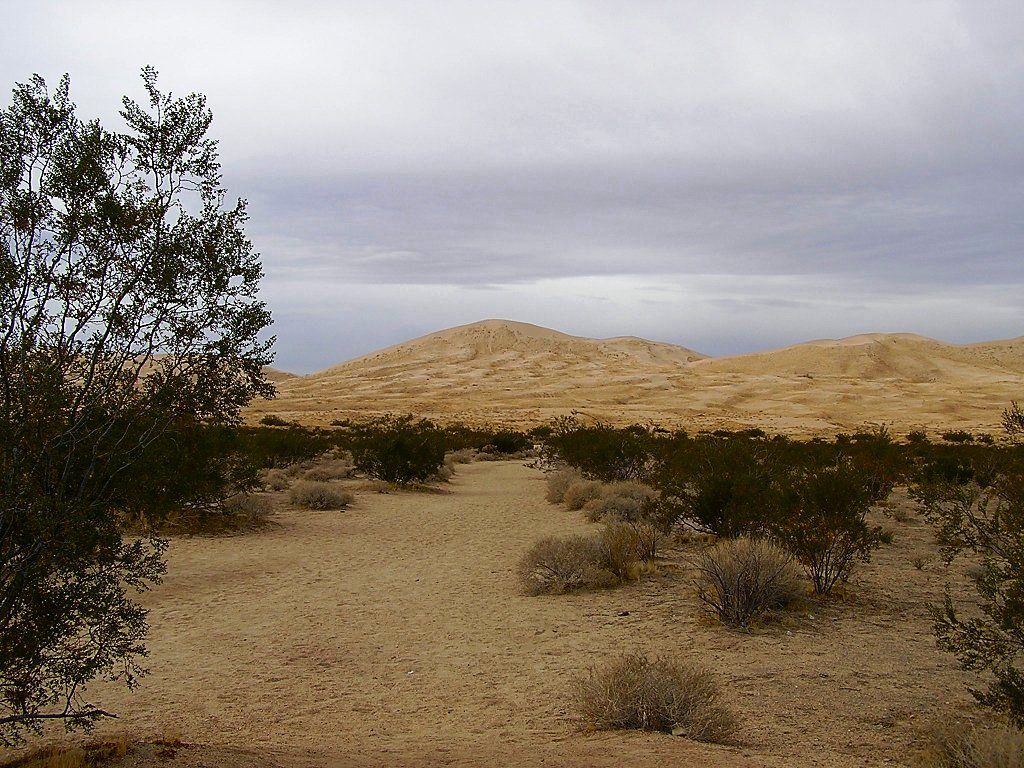
The massive Kelso Dune complex, home of the singing sand dunes in Mojave National Preserve
Mojave National Preserve's vast expanse of desert lands include elements
of three of the four major North American Deserts: the Mojave, Great Basin,
and Sonoran. The Preserve's unique ecology is attributed to its remarkable
geology. The desert is a land of old mountain ranges, sand dunes, great
mesas and volcanic features such as cinder cones, domes, and lava flows;
these features contribute to the remarkable beauty of the landscape. The
most ancient rocks in the preserve, found in the Clark Mountains, are
2.5 billion years old.
Flora and fauna
Changes in elevation and soil type, combined with dozens of seeps and
springs, many in sheltered canyons, create a wide range of microhabitats
that support a rich diversity of plants and animals. Some species are
only found in this area. Notable plant assemblages include one of the
largest and most dense Joshua tree forests, cactus gardens, and relect
plant communities of white fir and chaparral.
Signs of animal life are subtle and easily overlooked. Birds and lizards
are seen most frequently, but time of day, weather, and season all play
a role in determining which animals are active. A large percentage of
desert animals are nocturnal: being active at night rather than during
daylight hours allows them to avoid both high daytime temperatures and
predators. Typical nocturnal animals include most desert rodents, bats,
owls, mountain lion, skunks, and foxes. Other animals are crepuscular,
active at dawn and dusk, and include coyotes, bighorn sheep and jackrabbits.
Diurnal animals, those active during the day, are the most dynamic in
that their activity periods will change based on temperature and season.
Wildflowers in Mojave National Preserve
In ordinary years when winter and early spring rains are scanty, the annual flowering plants are few; inasmuch as they are in no particular way adapted to endure shortage of water, they wilt and die a few weeks after they have sprung, as if by magic, from the barren earth. As though trying to make up for this poor showing, every few years comes an abundance of rain and there results such a wealth of blossoms that almost every foot of sand or gravelly soil is hidden beneath a blanket of flowers.
Horsesback Riding in Mojave National Preserve
Horseback Riding in Mojave National Preserve
Horses and riders are welcome in Mojave National Preserve! Horses and/or other pack animals (llamas and mules) are permitted on all trails, backcountry roads, and open country (including wilderness areas) within the preserve.
Developed camping facilities are available at the Black Canyon Equestrian & Group Campground. Backcountry users should familiarize themselves with guidelines and regulations for backcountry travel and camping, as well as the following:
Free-trailing or loose-herding is prohibited throughout the preserve
Ranging/grazing is prohibited; Livestock must be fed certified weed-free
hay or pelleted food before arrival and during their stay in the preserve.
All manure should be raked out and spread over a large area.
Horse camps should be at least 200 yards from a water source.
Up to 7 animals are allowed per group; othwerwise, a Special Use Permit
is required.
Horse rentals are currently unavailable in the preserve. So, bring your
own horse (B.Y.O.H.).
Hunting in Mojave National Preserve
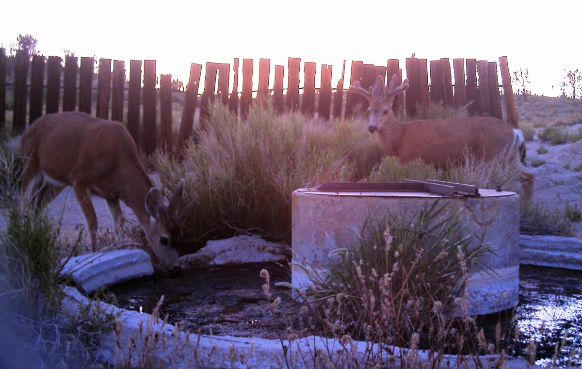
Mule deer at old water trough for Hunting in Mojave National Preserve
“I thought hunting was prohibited in national parklands…” Preserve staff often hear such questions, especially during the fall when hunters are afield pursuing quail, mule deer, bighorn sheep, and other wildlife. In general, National Park Service (NPS) regulations do prohibit hunting in national parklands—i.e., unless Congress specifically states otherwise in the unit’s founding or enabling legislation. In fact, as of today, hunting is authorized in 69 units of the National Park System. Where hunting is allowed, like in Mojave National Preserve, the NPS continues to provide a unique experience and support for an important American heritage and cultural value.
Hunting is permitted in accordance with California Department of Fish & Game (DFG) regulations. A California Hunting License is required; additional permits and tags may apply. Please be prepared to present your hunting license and/or tags if requested by an NPS park ranger or state game warden.
Firearms in Mojave National Preserve
The discharge of firearms is allowed only while legally hunting. Target shooting or “plinking” is prohibited. All firearms transported within the preserve must be unloaded, cased, and broken down, except during lawful hunting activities. No shooting is permitted within ½ mile of dwellings, hiking trails, campgrounds, information centers, Kelso Dunes, Fort Piute, or any other public gathering areas.
For more information about designated Safe Areas (San Bernardino Country ordinance), private property, wilderness access, and dates of specific hunting seasons, click here.
For more information about hunting in Mojave National Preserve, click here.
Climate in Mojave National Preserve
Below is the current temperature and weather forcast Mojave National Preserve
The weather is generally most comfortable in the spring and fall. Temperatures
vary greatly by elevation. At low elevations, daytime highs are in the
70s in March; lows are in the 40s. Highs over 100 typically begin in May
and can last into October. In the mountains, daytime highs are in the
70s in May; lows are in the 50s. Winters can bring freezing temperatures
and occasional snows, with daytime highs in the 50s and 60s.
Annual precipitation ranges from 3.5 inches at lower elevations to nearly
10 inches in the mountains. Most rain falls between November and April;
summer thunderstorms may bring sudden, heavy rainfall. The driest months
are May and June. Winds are a prominent feature of Mojave Desert weather.
Strong winds occur in fall, late winter, and early spring months.
Location of Mojave National Preserve
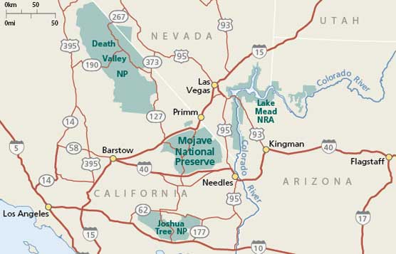
Map of Mojave National Preserve in Mill Valley, CA
For the location use following GPS cordinates of Mojave National Preserve 34°53'N 115°43'W.
Directions to Mojave National Preserve
located east of Barstow, Calif., between I-15 and I-40.
From I-15: Exit Kelbaker Road at Baker, Calif., or Zyzyx Road, Cima Road,
or Nipton Road.
From I-40: Exit Kelbaker Road, Essex Road, or Goffs Road.
Directions to Kelso Depot Visitor Center
From I-15: Exit Kelbaker Road at Baker, Calif., and drive south 34 miles to Kelso Depot.
From I-40: Exit Kelbaker Road (28 miles east of Ludlow, Calif.) and drive north 22 miles to Kelso Depot.
Directions to Hole-in-the-Wall and Mitchell Caverns
From I-40: Exit Essex Road and drive north 10 miles to the junction with Black Canyon Road. Mitchell Caverns is 6 miles northwest of this junction on Essex Road. Hole-in-the-Wall is 10 miles north on Black Canyon Road.
The address of Mojave National Preserve is Mojave National Preserve, Mill Valley, CA, 94941-2696 and the map is shown below:
Here is a detailed list of other National Parks of California besides Mojave National Preserve.
| National Parks of California | |||||||||||||||||||||||||
|---|---|---|---|---|---|---|---|---|---|---|---|---|---|---|---|---|---|---|---|---|---|---|---|---|---|
|
|||||||||||||||||||||||||
Camping Resources
Free Services
Free Text MessagesFree Picture Messages
Free Fax
Free Calls