Lassen Volcanic National Park - Guide to California's Lassen Volcanic National Park
Lassen Volcanic National Park is a United States National Park in northeastern California. The dominant feature of the park is Lassen Peak; the largest plug dome volcano in the world and the southern-most volcano in the Cascade Range. Lassen Volcanic National Park started as two separate national monuments designated by President Theodore Roosevelt in 1907: Cinder Cone National Monument and Lassen Peak National Monument.
The source of heat for volcanism in the Lassen area is subduction off the Northern California coast of the Gorda Plate diving below the North American Plate. The area surrounding Lassen Peak is still active with boiling mud pots, stinking fumaroles, and churning hot springs. Lassen Volcanic National Park is one of the few areas in the world where all four types of volcano can be found (plug dome, shield, cinder cone, and strato).
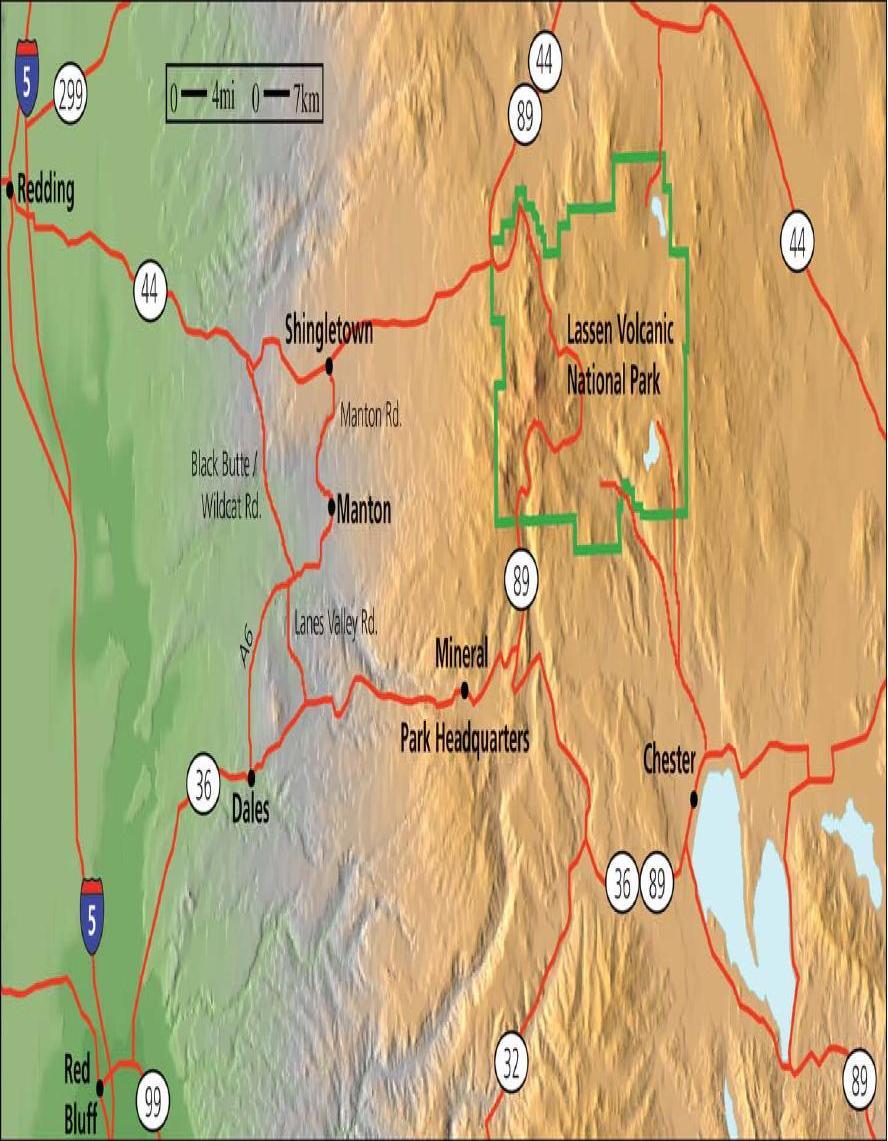
The park is accessible via State Routes SR 89 and SR 44. SR 89 passes north-south through the park, beginning at SR 36 to the south and ending at SR 44 to the north. SR 89 passes immediately adjacent the base of Lassen Peak.
There are a total of five vehicle entrances to the park: the north and south entrances of SR 89, and unpaved roads entering at Drakesbad and Juniper Lake in the south, and Butte Lake in the northeast. The Park can also be accessed by trails leading in from Caribou Wilderness to the east, as well as the Pacific Crest Trail, and two smaller trails leading in from Willow Lake and Little Willow Lake to the south.
A large lodge (the Lassen Chalet) with concession facilities formerly was located near the south-west entrance, but was demolished in 2005. A new, full-service visitor center was constructed in the same location, and opened to the public in 2008. Near the old lodge location was also located Lassen Ski Area, which ceased operation in 1992; all infrastructure has been removed.
Download here the Lassen Volcanic National Park Map.
Things to Do in Lassen National Park
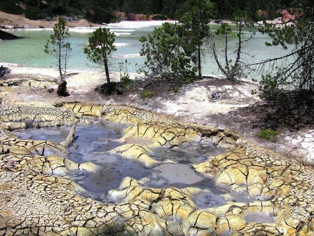
Several groups of hot springs and fumaroles, remnants of former volcanic activity, exist in Lassen Volcanic National Park. Most of these lie in or are closely adjacent to Mount Tehama's caldera. Bumpass Hell is the most spectacular of these, but others of importance are Sulphur Works, Little Hot Springs Valley, Boiling Springs Lake and Devil's Kitchen. In each thermal area, the highest temperature of water generally is close to the boiling temperature at the altitude of the particular spring or fumarole--198°F at Bumpass Hell and 191°F on the northwest flanks of Lassen Peak. Temperatures as high as 230°F have been recorded in the park.
Spring activity varies with water supply. Abundant water results in clear springs during early summer, but as the season progresses and the water supply decreases, springs change successively to turbid, warm pools, spattering mudpots, and finally steaming fumaroles. There are no true geysers within Lassen Volcanic National Park.
Gases from hot springs are composed mostly of steam and carbon dioxide, with minor amounts of other gases. These react with the rocks around the springs to ultimately form opal if temperature and acidity are high, and kaolin if they are low. Deposits of sulfur, iron pyrite (fool's gold), quartz and other substances are also found around the springs and in their runoff channels.
Solfataric alternation within the caldera of Mount Tehama covers about five square miles, much more extensive than the present hot springs basins--indicative of its former extent, and suggestive of its waning activity. It is the altered materials in the caldera which yielded most readily to the forces of erosion. Diamond Peak is a body of unaltered rock which still remains because it is more resistant.
Here is the map of geothermal activities thoughtout the Lassen Volcanic National Park.
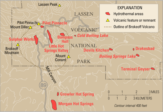
Sulphur Works and Little Hot Springs Valley
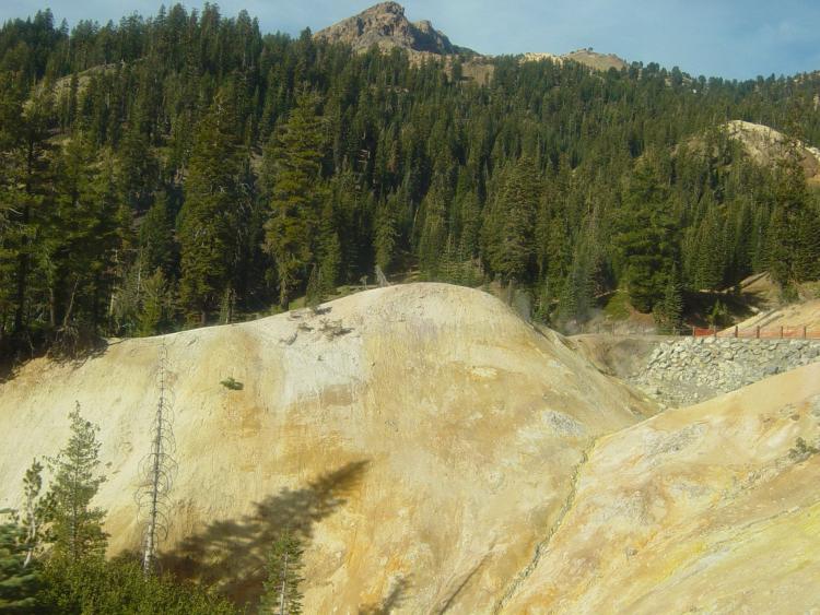
As in many hydrothermally active areas, the rocks at Sulphur Works and
Little Hot Springs Valley in Lassen Volcanic National Park have been chemically
altered into bright-colored clays. Sulfurous acid and sulfuric acid have
broken down hard, gray-green andesite lavas into red, yellow and buff
clays and iron oxides. Many visitors pass through Sulphur Works on their
way north on State Route 89 and sense the rotten-egg smell (hydrogen sulfide)
when they pass by a hot vent to the east of the road. Sulphur Works is
said to be the volcanic center of the ancestral Mount Tehama.
Bumpass Hell
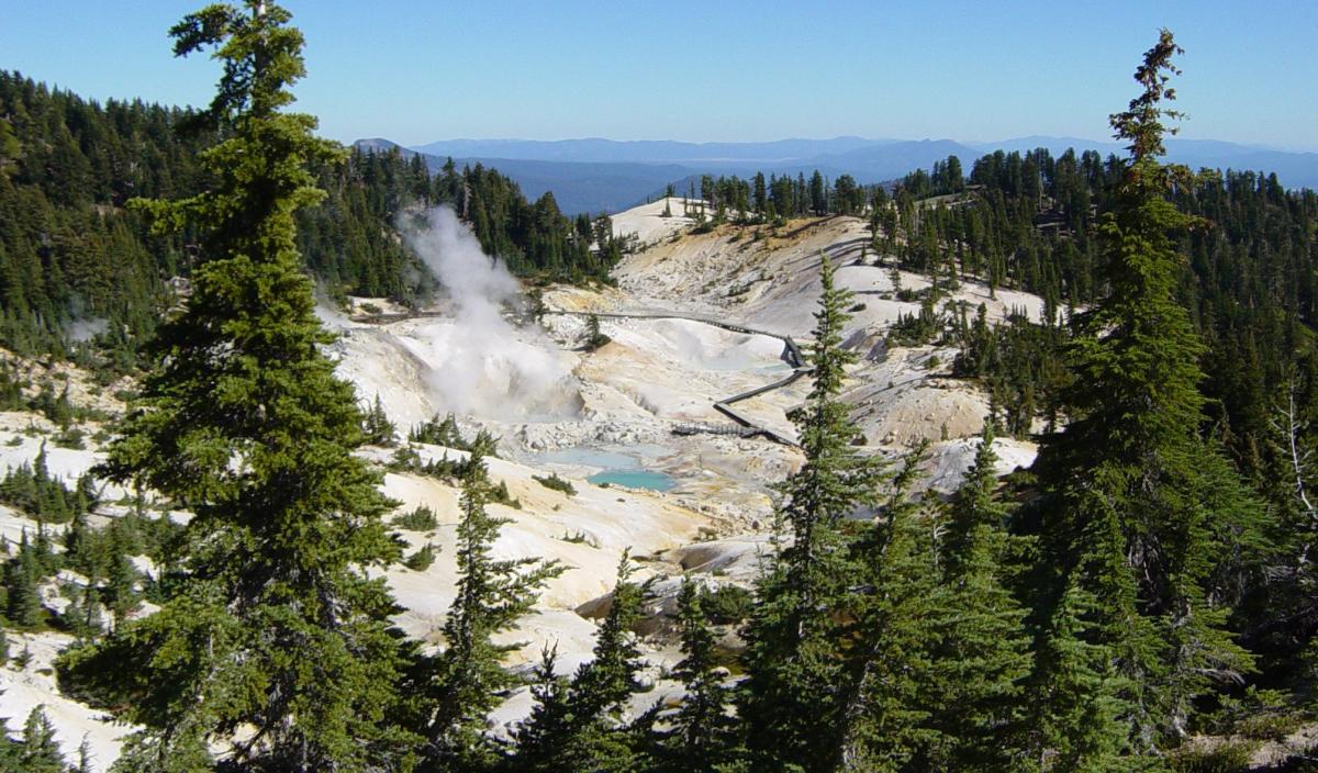
Near Little Hot Springs Valley is Bumpass Hell, which is a hydrothermally altered geothermal area that spans 16 acres (65,000 m²) and has hot springs, fumaroles, and mud pots. Never part of Mount Tehama's main vent, Bumpass Hell is the result of fissures that tap the volcanic heat (which is thought to be a cooling mass of andesite, perhaps three miles (5 km) below the surface).
It is named after Kendall Vanhook Bumpass, a cowboy who worked in the
Lassen area in the 1860s. One day Bumpass stumbled upon the area and his
leg was badly scalded when it broke though a thin crust above a mud pot.
He told his friends and townspeople about it, describing it as "hell."
A newspaper editor was interested in the story and convinced Bumpass to
take him to this place. Unfortunately, Bumpass' leg broke through the
crust again - this time it had to be amputated.
Devils Kitchen
About seven miles (11 km) southeast of Lassen Peak is Devils Kitchen.
In this geothermal area the hot springs are so acidic that they have eaten
pits and holes in the bedrock.
Terminal Geyser
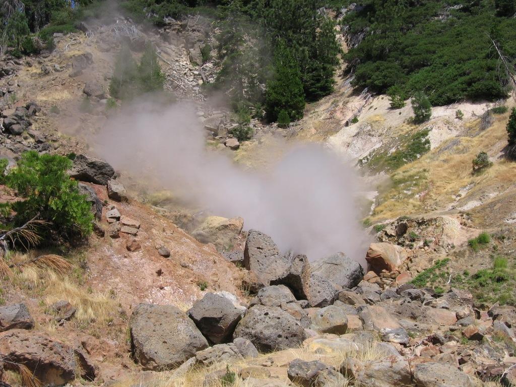
Located in the southeast corner of the park, Terminal Geyser is not actually
a geyser, but rather a cold stream flowing over a steam vent. This is
about 100 feet (30 m) from the site of a geothermal drilling operation
that took place in 1962 and 1978. The 4,008-foot (1,222 m) well is now
plugged and abandoned.
Boiling Springs Lake
Just northwest of Terminal Geyser, large, warm-water Boiling Springs Lake has many hot springs, mudpots, and fumaroles along its west shore. Unlike the more heavily visited areas of the park, this area is not developed with boardwalks or signs and offers a chance to view thermal features in a more natural setting.
Lakes of Lassen Volcanic National Park
Cliff Lake is a shallow glacial lake
Waterfalls of Lassen Volcanic
large waterfall in narrow canyon
Boating and Kayaking
Whether kayaking or canoeing, exploring Lassen Volcanic National Park can be an exciting and rewarding experience. Non-motorized boats must access Manzanita, Butte, and Juniper Lakes at their designated boat launch areas.
The following lakes are closed to all vessels.
Boiling Springs Lake
Emerald Lake
Lake Helen
Reflection Lake
Hat Lake
Bird-Watching
Over 83 species of birds nest in the Park. Raptors and other birds-of-prey are frequently sighted soaring above the rocky peaks between Brokeoff Mountain and Lassen Peak. The Manzanita Lake loop trail hosts many migratory birds and summer residents and is a favorite spot among bird watchers. The Cluster Lakes loop starting at Summit Lake is another trail popular among bird watchers.
Fishing
Whether fishing from shore with the kids, or fly-fishing Manzanita Lake from a float-tube, Lassen Volcanic National Park has plenty of opportunities to land the big one. Trout have not been stocked in the park since the 1980s, but a healthy population of these fiesty fish still remain in many lakes and streams (though not in all of them). Manzanita Lake is famous for its large rainbow and brown trout, but keep in mind it is catch and release only and you must use single-hook, barbless, artificial lures only. Butte Lake and Horseshoe Lake both have healthy populations of trout. A valid California fishing license is required to fish in the park, and please keep the regulations below in mind before wetting your line in the park.
The following areas are closed to all fishing during the periods indicated:
Manzanita Creek above Manzanita Lake - closed all year
Manzanita Lake shore from the boat launch northwest to 150 feet west of
the present inlet and 150 feet at the apex of a radius from the center
of the inlet - closed all year
Butte Lake boat launch - closed all year
Juniper Lake boat launch - closed all year
Day Hiking
Lassen Volcanic National Park's 106,372 acres provide a wealth of fun activities that are as varied as the seasons of the park.
There are over 150 miles of hiking trails within the park which range
in difficulty from a strenuous 5 mile round-trip hike up Lassen Peak to
a gentle 1.85 mile stroll around Manzanita Lake.
The Main Park Road provides incredible views of the Cascades and High
Sierras, as well as access to mountain lakes and active hydrothermal areas.
There are eight campgrounds within Lassen Volcanic National Park, and
a large part of Lassen's wilderness is available for wilderness camping
with a free permit.
Lassen Volcanic National Park offers a wide variety of Ranger-led and Junior Ranger programs throughout the summer and winter seasons.
Loop Trail Distances table and descriptive hiking
trails map (click here to download the pdf) .
Day
Hike Guide (click here to download the pdf)
Hiking Trails by Region
South Park Road Region
Mill Creek Falls (moderate, 4.6 miles round trip)
Brokeoff Mountain (strenuous, 7 miles round trip)
Ridge Lakes (moderate/strenuous, 2.0 miles round trip)
Bumpass Hell (moderate, 3 miles round trip)
Lassen Peak (strenuous, 5 miles round trip)
Cold Boiling and Crumbaugh Lakes (easy - moderate, 2.6 miles round trip)
Terrace, Shadow, and Cliff Lakes (moderate, 4 miles round trip)
Kings Creek Falls (moderate, 3 miles round trip)
Sulphur Works (easy)
North Park Road Region
Echo Lake (moderate, 4.4 miles round trip)
Paradise Meadow (moderate, 2.8 miles round trip)
Manzanita Lake (easy, 1.5 miles round trip)
Lily Pond Nature Trail (easy, 1 mile round trip)
Devastated Area Interpretive Trail (easy)
Crags Lake (moderate, 4.2 miles round trip)
Manzanita Creek (moderate, up to 7 miles round trip)
Butte Lake Region
Cinder Cone (strenuous, 4 miles round trip)
Prospect Peak (strenuous, 7 miles round trip)
Warner Valley, Drakesbad, and Juniper Lake Region
Mount Harkness (moderate, 3.8 miles round trip)
Devil's Kitchen (moderate, 3 miles round trip)
Boiling Springs Lake (moderate, 3 miles round trip)
Here is a detailed list of other National Parks of California besides Lassen Volcanic National Park.
| National Parks of California | |||||||||||||||||||||||||
|---|---|---|---|---|---|---|---|---|---|---|---|---|---|---|---|---|---|---|---|---|---|---|---|---|---|
|
|||||||||||||||||||||||||
Camping Resources
Free Services
Free Text MessagesFree Picture Messages
Free Fax
Free Calls