California Camping
California Camping SitesNational Parks of California
California State Parks
State Parks Camping Fees
State Parks Day Use Fees
State Parks WiFi Access
Sonoma Coast State Parks on the Beach - Guide to Sonoma Coast State Beach
Sonoma Coast State Beach in Jenner, California (in Sonoma County)
Long sandy beaches below rugged headlands, a craggy coastline with natural arches and secluded coves are features that make Sonoma Coast State Park one of California's most scenic attractions.
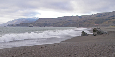
The Beach, actually a series of beaches separated by rock bluffs and headlands, extends 17 miles from Bodega Head to Vista Trail located 4 miles north of Jenner. Beachcombers, fishermen, sunbathers and picnickers can access the beach from more than a dozen points along coast Highway 1.
While the north coast weather can be foggy in the summer, it usually burns off by midday and the cool ocean breezes make the Sonoma Coast a haven for visitors seeking to escape the inland heat.
Sonoma Coast State Beach is a State of California property in Sonoma County consisting of public access use on lands adjoining the Pacific Ocean. This extent of beach runs from a coastal point about 4 miles (6 km) north of Jenner and continues for approximately 17 miles (27 km) to the south to terminate at Bodega Head. The property lies along State Route 1 and consists of a number of named beaches including Arched Rock Beach, Gleason Beach and Goat Rock Beach. The ecosystem consists of alternating sandy beaches and rocky shoreline, with a marine terrace extending above the entire extent with an upland California coastal prairie habitat.
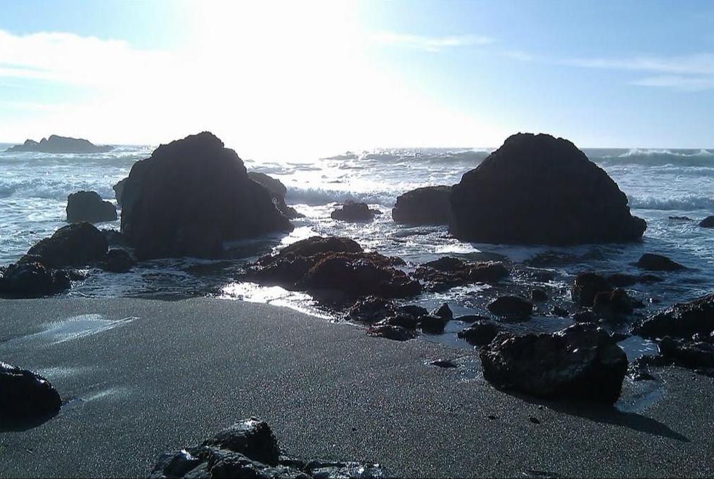
Geology in Sonoma Coast State Beach
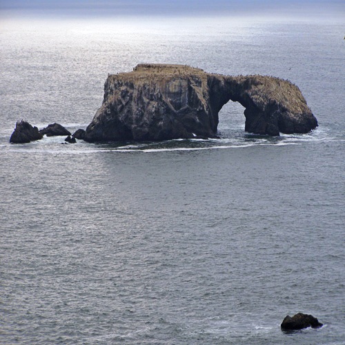
Arched Rock, formed by wave action collapsing a portion of this sea stack (north of Bodega Head, Calif.)
This strip of coastal property is subject to continuing marine erosion
as well as windborne erosion, thus creating a situation where an average
of one to three feet (30 to 90 cm) per year of land mass is lost. Obviously
in years of heavy storms this value can be higher, whereas, in a less
stormy year the land erosion can be lower. Over the last geologic epoch
the land has been subject to uplift, a process which has created a marine
terrace of the entire extent of the property. This marine terrace is elevated
approximately 50 to 100 feet (15 to 30 meters) above mean sea level, which
results in a steep bluff directly above the littoral zone.
Vertical rock formations are a geological hallmark of this site, and have
weathered far less than the bulk of the soils. These features are known
as sea stacks, and they appear standing out of the water or on the beach
as though as sculptures placed decoratively along the shoreline. Occasionally
these stacks appear as adornments on the marine terrace, indicating their
ancient origin on the sea floor prior to uplift. These rock formations
are composed of sandstone with layers of quartz.
The active San Andreas Fault runs roughly parallel and near to the coastline
of Sonoma Coast State Beach. Soils within the site are classified as coastal
beach sands (where rocky shoreline is not evident) and marine escarpment
group soils on the marine terrace; typically soils above the marine terrace
are in the Rohnerville loam group. Most of the beach sands consist of
a medium coarse brown to gray sandy materials, reflecting the high rate
of erosion of escarpment soils into the ocean; however, there are patches
of smooth pebble beach such as the approximately one hundred meter stretch
lying immediately north of Goat Rock.
Ecology in Sonoma Coast State Beach
Coastal prairie at Sonoma Coast State Beach with rocks rubbed by mammoths
and also arched rock formation as evidence that this terrace was once
on the sea floor.
The habitats include marine, littoral and coastal prairie. In the marine
environment are found gray whales, harbor seals and California sea lions
as well as a multitude of fish species and other marine organisms. There
are also modest kelp beds and other marine vegetation. The littoral beach
environment has fewer organisms than more southerly zones, because of
the colder temperatures; however, there are tidepools which are abundant
with marine flora and fauna.
The coastal prairie soils are moderately well drained and granular in
nature with moderate soil permeability; these features lead to slight
erosion potential and moderately high bio-productivity. Acidity of these
loamy soils is medium to high, and thus some vegetative stunting and hospitality
to rare plants is offered. The upland environment on the coastal prairie
offers a variety of grasses and wildflowers including varieties of lupine,
thistle and wild oats. The typical annual plant productivity is approximately
3,300 lb (1,500 kg) per acre (3700 kg/ha) of air-dried yield per annum
in an abundant moisture year, and about half that amount in a very dry
year. A variety of birds and mammals thrive on the coastal prairie including
numerous California Mule Deer, Odocoileus hemionus californicus.
History of Sonoma Coast State Beach
Some of the oldest natural history of this area related to mammals are
a rock formation about one mile (1.6 km) south of the Russian River. There
is found a sea stack formation with prominent rubbing marks about two
to four meters in elevation, a height too high to have been caused by
modern bovids. Mammoths are believed to have roamed here as recently as
40,000 years ago, and they are thought to have created these severe rubbing
marks. Mammoth fossil remains have been found at Bodega Head at the south
end of Sonoma Coast State Beach.
Earliest known human settlement of this site was by the Native American
Coast Miwok and Pomo tribes. As early as 1849 archaeological finds were
recorded on this property, and to date dozens of prehistorical kitchen
middens and other types of tribal habitation finds have been made. The
property is part of the Mexican land grant Rancho Bodega. The Russians
are thought to have begun logging the old-growth forests directly above
the coastal prairie in the early 19th century.
Duncans Point
The underwater delineation of the property is considered to extend to 1,000 feet (300 m) from the shoreline. While no shipwrecks have been discovered, the literature indicates that there are 17 vessels which may have been lost in these waters. There are remains of numerous historic barns and other agricultural buildings on the coastal prairie indicating 19th century settlement by Europeans; at Duncans Point there are iron pins embedded in the sandstone bluffs as evidence of the active shipping industry here in the late 19th century and early 20th century.
Camping in Sonoma Coast State Beach
Wright's Beach
There are 27 developed campsites located adjacent to the beach. There are no showers, but campers may use the hot showers at nearby Bodega Dunes Campground. Maximum trailer length is 27', no hook-ups are available. Each site has picnic tables, fire rings and paved parking spurs. Running water and flush toilets are nearby. When the campground is filled, the overflow area in the Wright's Beach Picnic Area may be used for self-contained vehicles. This area is along the roadway adjacent to the kiosk. Reservations are recommended, especially on the weekends and during the peak season.
Aerial photos of Wright's Beach & Campground
Bodega Dunes Camping
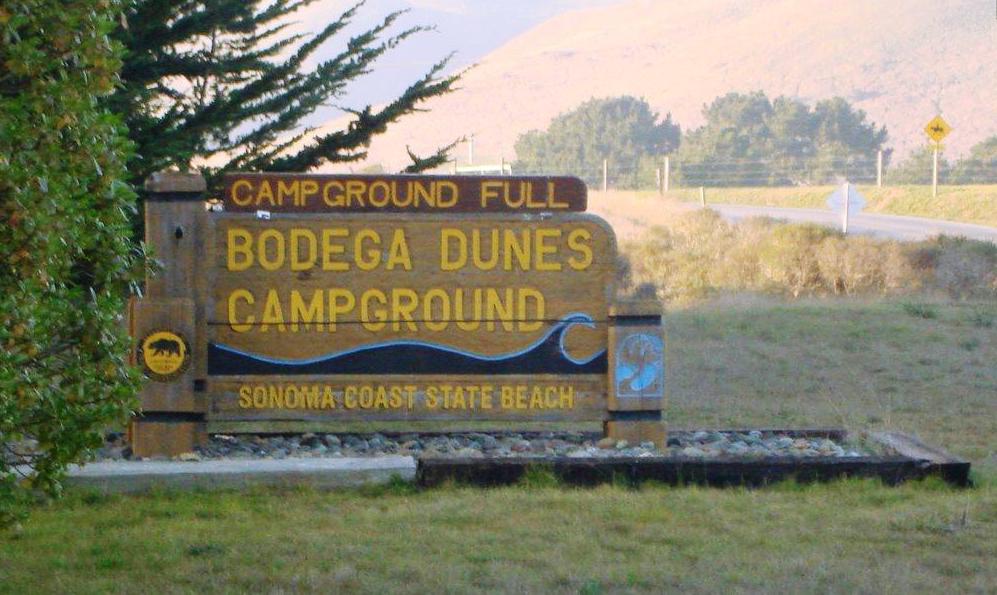
Bogega Dunes Campground Entrace (Just North of Bay Hills Road)
There are 98 campsites with hot showers, flush toilets, and a trailer sanitation dump station. Maximum trailer length is 31', no hook-ups are available. Campfire and Junior Ranger programs are held in the summer months. The day use area includes a disabled accessible boardwalk out to a classic sandy beach. No DOGS and NO FIRES are allowed on the beach as a measure to protect the snowy plovers. The western snowy plover is listed under the Federal Endangered Species Act as a threatened species because of loss of nesting habitat due to human development, invasion of European beach grass and predation by ravens, foxes, domestic dogs and cats.
Willow Creek Environmental Camping
11 primitive campsites with fire rings, picnic tables, and pit toilets. Campsites are within 1/4 mile from the parking lot and there is no running water. The only State Park campground on the Russian River, sites are shaded by willows but close to a large beach for swimming and fishing. Blue heron, egrets, osprey, and occasionally river otters can be seen by the river. To protect the wildlife, no dogs are allowed. These sites are not on the reservation system.
Pomo Canyon Environmental Camping
20 campsites with fire rings, picnic tables, pit toilets and running water nearby. Campsites are within 1/4 mile from the parking lot, one is disabled accessible. Camps are set in a beautiful redwood grove among the ferns. A three mile trail to Shell Beach takes off from the campground, crossing seasonal streams and rising up into the grassland with marvelous views of the river and finally the ocean. To protect the wildlife, no dogs are allowed. This campground is not on the reservation system.
Sonoma Coast Trail
Sonoma Coast Trail Map
Length: From Blind Beach to Shell Beach is 4 miles round trip; to Wright's Beach is 6.5 miles round trip.
The names alone are intriguing: Blind Beach and Schoolhouse Beach, Arched Rock and Goat Rock, Penny Island and Bodega Head.
These colorfully named locales are some of the highlights of Sonoma Coast State Beach, thirteen miles of coastline stretching from the Russian River to Bodega Bay.
Sonoma Coast State Beach is not one beach, but many. You could easily overlook them, because most aren't visible from Highway 1. The beaches are tucked away in rocky coves, and hidden by tall bluffs.
Sonoma Coast Trail is a pretty blufftop route that connects some of these secret beaches. During spring, wildfowers brighten the bluff: blue lupine, Indian paintbrush and sea ?g.
Sonoma Coast Trail begins on the bluffs above Blind Beach, but the walker can also begin at Goat Rock, located a half mile north of the trail-head. The rock is connected to the mainland by a causeway. During the 1920s, Goat Rock was quarried, and used to build a jetty at the mouth of the Russian River.
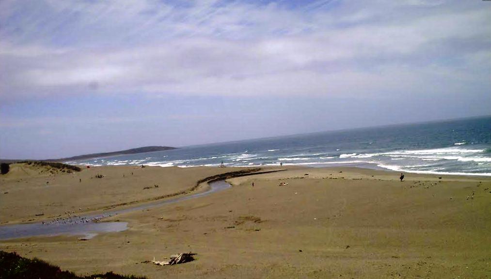
A mile north of the trailhead, and
0.5 mile north of Goat Rock is the mouth of the Russian River. The 110
mile-long river is one of the largest on the North Coast. At the river
mouth, you can observe ospreys nesting in the treetops. The California
brown pelican is one of several species of birds that breed and nest on
Penny Island, located in the river mouth.
Directions to trailhead: From Highway 1, ten miles north of the town of Bodega Bay, turn west on Goat Rock Road. Signed Sonoma Coast Trail begins at a small parking lot on the left of the road. If you'd like to begin this walk at Goat Rock, continue to road's end at a large parking area.
The hike: Sonoma Coast Trail heads south along the edge of the bluffs. Soon, you'll step over a stile and head across a pasture. The trail climbs to a saddle on the shoulder of Peaked Hill (elevation 376 feet).
You then descend to the at blufftops, and cross a bridge over a fern-lined ravine. It's a pastoral scene with grassy bluffs and a weathered old barn in the distance.
After crossing another ravine, the path reaches the Shell Beach parking area. A short trail descends the bluffs to Shell Beach. Another trail extends northwest, crosses the highway, and reaches redwood-shaded Pomo Canyon. Picnic tables and walk-in (environmental) campsites are located near the creek.
Sonoma Coast Trail continues south, detouring inland around a private home, then doubling back seaward. The trail plunges into Furlong Gulch, then switchbacks back up to the bluffs. You can follow the trail or the beach to Wright's Beach Campground.
Facilities & Activities in Sonoma Coast State Beach
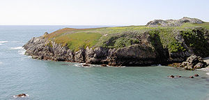
Bodega Head is the rocky headland that forms the entrance into Bodega Harbor. The harbor side provides a popular crabbing area along the jetty, and the many hiking trails on the ocean side allow access to small, sandy coves and spectacular scenic blufftop views. The high cliffs offer excellent vantage points for observing migrating gray whales.
Photos of Bodega Head
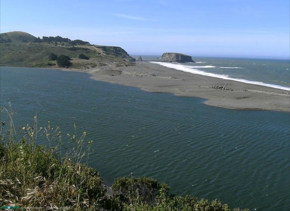
Photos of mouth of the Russian River with Goat Rock in the background
Goat Rock, near the mouth of the Russian River, is known for its scenic shoreline and easily accessible sandy beach. Picnic tables and restroom facilities are also available. Goat Rock beach is home to a colony of harbor seals which are fun to watch, but please stay 50 yards from the seals, especially during pupping season (March - August.). Due to the protected status of the seals, NO DOGS are allowed on Goat Rock Beach.
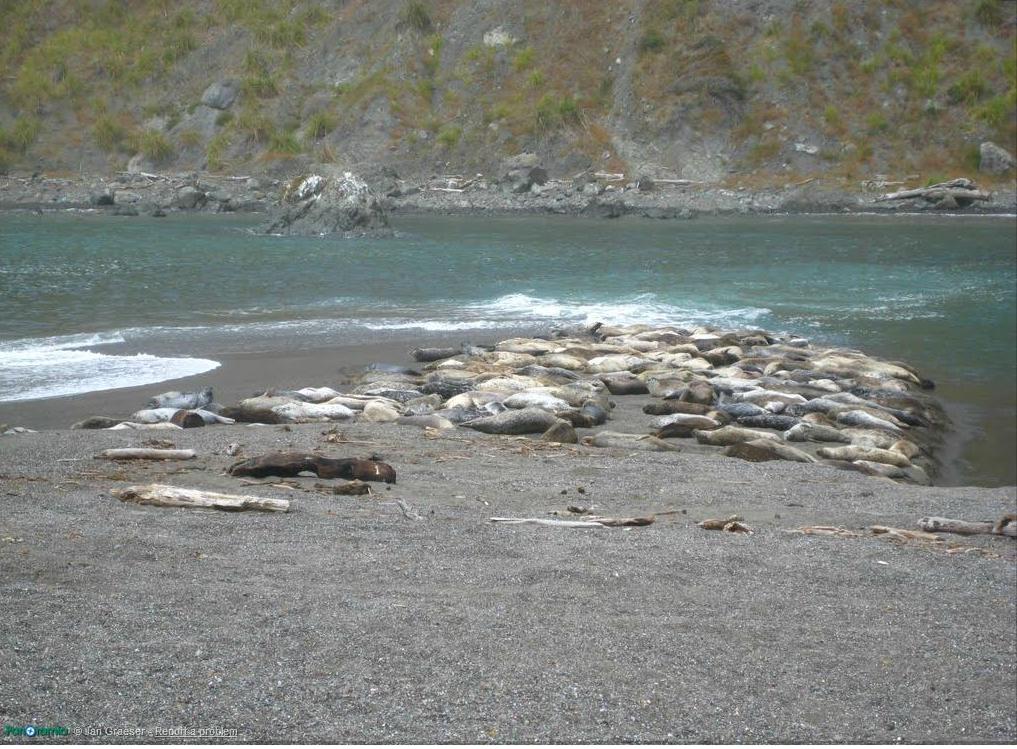
Seal Colony in mouth of the Russian River
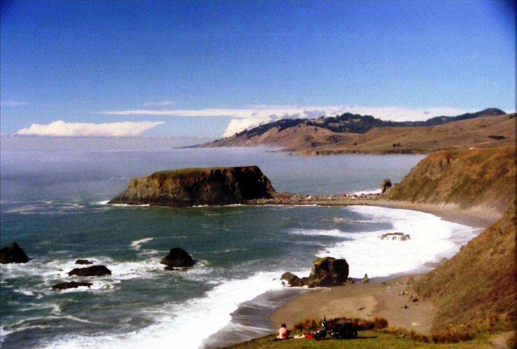
Photo of Goat Rock Beach
Shell Beach is a favorite location for beachcombing and tidepooling. It is used by schools as an outdoor classroom for the study of tidal pool marine life and enjoys a reputation as a prime fishing spot.
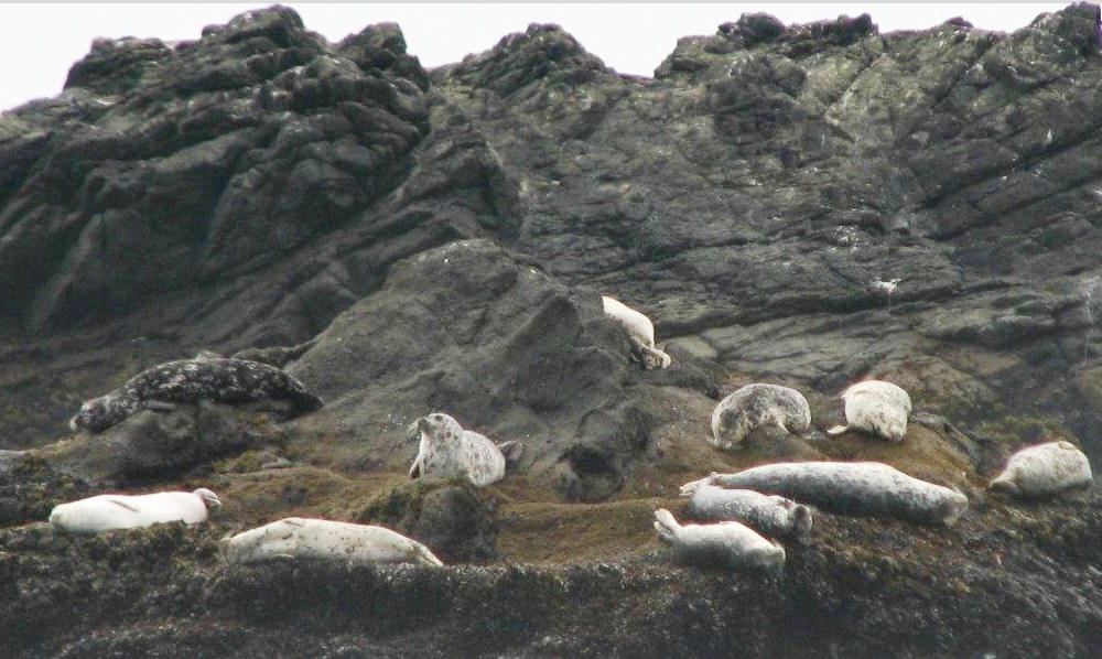
Harbor Seals in Shell Beach 50 feet offshore in lava rocks just south of Pacific View Drive
Duncan's Landing is famous for two things: as an early-day landing for loading small coastal ships with lumber and food products and for being the most dangerous point along the Sonoma Coast due to large and unpredictable surf. Heed the signs and stay off the rocks, the waves have come up to the parking lot and people have been swept off the rocks. In the spring the wildflower displays are spectacular.
Photos of Duncan's Landing
Portuguese Beach & Schoolhouse Beach are beautiful sandy beaches surrounded by rocky headlands. Rock fishing and surf fishing are popular in these locations.
Photos of Portuguese Beach
Photos of Schoolhouse Beach
Salmon Creek Beach, where a lagoon forms as sand closes the mouth of Salmon Creek, is a popular summer destination. Nearly two miles of unbroken, scenic, sandy beach make this an excellent place for surf fishing, beachcombing, and picnicking. The surfers are here when the waves are good. NO DOGS and NO FIRES are allowed on Salmon Creek Beach due to the protection of the snowy plovers. The western snowy plover is listed under the Federal Endangered Species Act as a threatened species because of loss of nesting habitat due to human development, invasion of European beach grass and predation by ravens, foxes, domestic dogs and cats.
Salmon Creek Beach
Causion when visiting the beach
Like most north coast beaches, Sonoma Coast is NOT FOR SWIMMING. Strong rip currents, heavy surf and sudden ground swells make even surf play dangerous. A small staff of well-trained lifeguards are usually on duty during the peak season, but with so much coastline to cover they may not be available.
It is especially important to keep children back from the highest water-line and never turn your back to the ocean. Many rescues are made each year. Also be careful of the bluffs and rocks. The shale formations are unstable and unsafe for climbing, so stay on the trails and heed warning signs.
Location of Sonoma Coast State Beach
The Sonoma Coast State Beach is located at 38°22'8.39"N 123°4'25.28"W. The Sonoma Coast State Beach is The beach is located between Jenner and Bodega Bay on Highway One. The Rangers' Station is at the north side of Salmon Creek, off Highway 1. The address of Sonoma Coast State Beach is 4400-4698 Coast Hwy, Bodega Bay, CA 94923. Sonoma Coast State Beach can be contacted at 707-875-3483.
Here is a driving map to Sonoma Coast State Beach.
Here is a detailed list of other state beaches of California besides Sonoma Coast State Beach.
| California State Parks on the Beach | ||||
|---|---|---|---|---|
|
||||
Camping Resources
Free Services
Free Text MessagesFree Picture Messages
Free Fax
Free Calls